Leading Quality Trails
The 20 ERA – Certified Trails in Europe
A brief presentation of the 20 Certified European Trails, Menalon Trail was the seventh that joined the club on the 31st of May 2015.
Leading Quality Trail Certification procedure
An interesting region (tourism body, National Park, walking group, etc.) contacts the ERA to start the quality process. The ERA offers a 2-day European-wide uniform course for assessors in the region. The trained persons gather the data necessary for the quality assessment on the trails and assess them initially (analysis of strength and weakness). Thus shortcomings in the quality of the route can be identified quickly and possibilities for upgrades can be found. When the route fulfills the ‘Quality route’ criteria, an application for certification can be applied for with the ERA. The data gathered on the route are independently assessed and analyzed by the ERA. Qualified ERA personnel carries out spot checks on the route locally. When the results of the checks are positive, the route gets the certification ‘Leading Quality Trails’ for a period of 3 years. After this time, the quality of the route has to be tested again. The quality mark can be used in printed matter and on the internet to market the walking route. The ERA appointed the Deutscher Wanderverband Service Ltd. with the implementation of the ‘Leading Quality Trails – Best of Europe’.
Nature Conservation
The proposer confirms that the route of the walking trail complies with all environmental protection regulations (particularly in sensitive areas like nature reserves, biotopes, etc.).
Maintenance
The proposer guarantees for the complete period of use of the certification that maintenance of the trail – surface and furniture – is ensured. The ongoing regular inspections and care have to be documented and sent to the ERA. The fundamental principles of ERA way marking apply (Bechyné/ Czech Republic, 2004). Οι τρέχουσες επιθεωρήσεις καθώς και η φροντίδα του συντάσσονται σε κείμενο και αποστέλλονται στην ERA. Οι θεμελιώδεις αρχές της ERA εφαρμόζονται. (Bechyné/ Czech Republic, 2004)
Validity period
The certification period starts with the handing over of the certificate and runs for 3 years.
Co-operation
All affected interest groups that are part of the quality process in the trail region have to be involved by the proposers from the very start. Interested parties can include forest services, NPWS, tourism groups, mountaineering organizations, walking clubs, landowners, local authorities, and communities.
A brief presentation of the 20 already certified European trails follows.
Lechweg
Easy long-distance hiking through an alpine region which is also one of the last wild river landscapes in Europe: The “Lechweg – from the Spring to the Falls”. Just in time for the 2012 hiking season an alpine region offers easy long-distance hiking for the very first time. It is also the first cross-border long-distance path certified according to the quality criteria of the European Ramblers Association (ERA). On approximately 125 kilometers of trail, the Lechweg leads from the lake Formarinsee near the community of Lech am Arlberg, over Warth, into the Nature Park Region of the Lech Valley-Reutte and to the Lech Falls in Fuessen in the Allgaeu, thereby joining three regions and two countries with their traditions and stories. For further information and news visit www.lechweg.com.
Escapardenne Eisleck Trail
On both sides of the Belgo-Luxembourg border, in the midst of the central Ardennes, of the Oesling, you will discover 104 km of trails leading you from small discrete discoveries – an ancient cross, dry stone walls, streams… – to vast views! Gossamer mists, peaceful dairy pastures, the fleeting appearance of a deer, a freshly mow meadow filling the air with a pleasant fragrance – a wealth of impressions and images so that the memory of your “escapade in the Ardennes” will stay with you! The Trail can be discovered in 5 or 6 stages. For further information and news visit www.escapardenne.eu.
Kullaleden
Kullaleden is a trail around the Kullahalvön peninsula from Helsingborg to Utvälinge via Kullaberg in Southern Sweden. Kullaleden is 70 km long and offers a great variety of experiences along the way. Here you find everything including the medieval city center of Helsingborg, beautiful views over the straits from the plateau heights, the well-known Sofiero Palace, Kulla-Gunnarstorp, and Krapperup Estates, beaches and picturesque seaside villages, and Kullaberg’s dramatic cliff formations. Kullaleden is certified according to the European Ramblers’ Association’s (ERA) criteria for being a Leading Quality Trail. Nature reserves exist along large portions of the trail. Within these reserves, specific codes of conduct exist in order to protect their natural and recreational values – camping is for example prohibited. For more information, read the signs for each individual reserve or on www.kullaleden.se.
Mullerthal Trail
Hiking through rock crevices of the Luxembourg sandstone, through forests, light-filled valleys, and along small streams – all these options are offered by the fantastic world along the Mullerthal Trail. Extraordinary natural phenomena such as the luminous moss reflect the power of nature. Faces and figures emerge from the rocks. Those who know the legends and myths of the region are sure to see fairies flit through the forest here and there. On its 112 km, the Mullerthal Trail leads through the varied landscapes of the Mullerthal Region – Luxembourg’s Little Switzerland. On the three main trail routes, hikers can enjoy regional peculiarities as bizarre rocks, mossy forests and quaint stream valleys but also open pastures. Again and again the Mullerthal Trail leads to beautiful viewpoints and cultural sites. The three routes of the Mullerthal Trail each have their own character. Route 1 provides the change of landscapes typical for the region: rocks, woods and meadows. Route 2 leads through the heart of Luxembourg’s Little Switzerland and brings hikers to spectacular rock formations. Route 3 is characterized not only by the rocks but above all by enchanting stream valleys and romantic castles. According to time and condition, the hiker may undertake unidirectional or circular tours, from the many different starting points of the Mullerthal Trail. Four ExtraTours complete the offer. For more information and updates visit www.mullerthal-trail.lu.
Veldenz Wanderweg
The Lichtenberg Castle, ancestral seat of the counts of Veldenz high above the village Thallichtenberg marks the beginning of the hiking trail through the heights of the Palatinate hill-country to the little city of Lauterecken. The certified trail displays long periods of hiking in a natural silence that is hard to find nowadays. It’s almost 60km to hike between the Lichtenberg Castle and the Veldenz-residence Lauterecken, hikers should take their time to enjoy the trail. Recommended are five day-trips for almost a week hiking-adventure – the Veldenz trail leads through many different types of landscape. It’s sometimes like stepping back in time: narrow paths especially in the nature reserve “Mittagsfels” climb up in an almost alpine scenery with rare flowers and an incredible sight – and you’ll hear nothing but your footsteps and the birds singing. The history and culture of the Palatinate hill country arise from the past in the sights of the Lichtenberg Castle, the water-castle of Reipoltskirchen with the path of sculptures, and the Veldenz castle in Lauterecken. More information on www.veldenzwanderweg.de.
Moselsteig
The Moselle flows through one of the most beautiful cultural landscapes in Europe. Countless time witnesses of more than 2000-year-old history, forests, vineyards, wonderful villages, and, of course, the wine characterize the landscape and the people. And it is the Moselsteig that creates a unique connection of all that and that accompanies the entire flow of the Moselle, starting in German-French-Luxembourg border town Perl up to the Mouth of the Moselle in Koblenz. Who is going to walk this quality trail can look forward to an unusually diverse experience. Already its complete length of 365 kilometers impresses. With its 365 kilometers, the Moselsteig is one of the longest long-distance trails in Germany. Its 24 stages are quite different: it is sometimes easy, sometimes hard to walk them. They lead through forests, vineyards, along the banks of the Moselle just as along slope edges with viewpoints – so that any walking preferences and requirements can be met. They impress both with nature closeness and with a rich history. Countless spectacular viewpoints provide unforgettable views. And the attached circular paths invite additional excursions. But one thing is omnipresent: the famous Moselle wine and countless possibilities where you can taste it during a stopover or during a night-stay. On the homepage, you will find detailed information for all the stages – inclusive tour planner and the possibility to download GPS-tracks or to print the complete tour including the map, the height profile, and description for the preparation of your walk. More information on www.moselsteig.de.
Albtraufgänger
Meeting the unique landscape of Albtrauf becomes an unforgettable experience: juniper heaths, orchid meadows, and striking cliffs characterize the “Experience region Schwäbischer Albtrauf”. The features of the region are the gentle hills, distinctive panoramic views, delicate gourmet cuisine with regional specialties, and a lot of healing springs. The over 100 km long Albtraufgänger leads through small villages and connects history and art with local traditions. The route of Albtraufgänger captures all charming aspects of the region and offers both relaxation and adventure. The Albtraufgänger was certificated both as “Qualitätsweg – Wanderbares Deutschland” and “Leading Quality Trails – Best of Europe” For more information please visit www.mein-albtrauf.de.
Menalon Trail
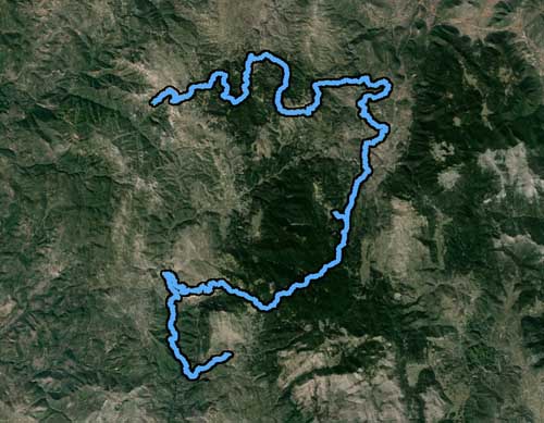
The Menalon Trail is a long mountain trail of 75 Km in Arcadia. The trail crosses 9 villages and uses parts of an infinite trail network, which were then rearranged in a serial structure and signposted systematically by a large group of volunteers from Eastern Gortynia and the participation of the Club of Mountaineers and Ecologists of Arcadia (SAOO) under the coordination of the 10 volunteers trained by the ERA team (the funding of the signage and expenses were covered by local businesses and associations). The design and creation of the information and orientation signs were made by Society for the Environment and Cultural Heritage with the funding of the Leventis Foundation. The mapping of the area, the construction of the web and mobile applications as well as the software application to plan the signposting was undertaken by the AnaDigit cartographic company. The certification control costs were covered by the Municipality of Gortynia. The design and organization of the Menalon Trail, as well as the overall infrastructure that surrounds it, conforms to the standards set by the European Ramblers Association for the certification of walking networks complying to a criteria system of 41 quantitative, technical and qualitative parameters, in order to be certified and proposed to walkers from all over Europe as a reliable, attractive and safe mountain adventure. More information at www.menalontrail.eu
Escapardenne Lee Trail
Consolidated under the umbrella of the Escapardenne, two ‘Leading Quality Trails – Best of Europe’ with total length of 159 km, traverse the Belgian-Luxembourg Ardennes. The shorter Lee Trail leads from Ettelbruck to Kautenbach across narrow paths past countless slate ridges, through the quiet valleys of the rivers Sauer and Wiltz before it finally joins its bigger brother, the cross-border Eislek Trail. Constantly running alongside the railway connection Luxembourg – Troisvierges, the Lee Trail is a hiking trail for all sporty hikers in search of pristine nature away from trodden paths. You will find numerous Lee-crests (rock in Luxembourgish), that give the trail its name. In doing so, admirable views ensure that the strenuous ups and downs are always quickly forgotten. For more information please visit www.escapardenne.eu.
Gendarmstien
The Gendarme path is one of Denmark’s most beautiful walking routes and follows the scenic landscape along the coast of the Flensborg Fjord. The 74 km path takes you from Padborg on the main land to Høruphav on South Als. The Gendarme path is the former border guard patrol path between Denmark and Germany. It was in use from 1920 until 1958, when each gendarme (or border guard) had a specific section of the coastline to patrol. While walking along the water as near they could a small walking path was created. On the way you will see: historic environment and cultural landscapes, industrial heritage, unspoiled nature and beautiful views from vantage points along the route, a landscape shaped by the glacier that covered the area 10,000 years ago. The route is divided into 4 stages, leading you through forests, bird sanctuaries, small fishing villages and farmland, past historic brick works, the Summer Residence of the Danish Queen, a late 19th century Artist Colony, the battlefields of the 1864 War at Dybbøl, and fine examples of Danish and German architecture. For more information please visit www.gendarmsti.dk
Rota Vicentina
Rota Vicentina is a network of walking trails in Sw Portugal, totaling 400 km to walk, along the most beautiful and best preserved coastline of Southern Europe. Comprising the Historical Way, the Fishermen’s Trail and several Circular Routes, proposes a unique experience of two worlds, between a living and authentic rural culture and a surprisingly wild coastline – fully within Sw Alentejo and Vicentina Coast Natural Park. The route is fully marked in both directions, and can be traveled independently and in total security, preferably from September till June. The sections in which is divided are mere suggestions and can be shortened or extended according the preferences, or the location of the hiker’s accommodation. In February 2016, the Historical Way of the Rota Vicentina has been certified by the European wide label “Leading Quality Trails – Best of Europe”, joining the exclusive group of the best walking destinations in Europe. For more information please visit www.rotavicentina.com
Zeugenbergrunde
You may physically feel the epochal geological processes that formed the landscape around the pleasant city in the northern part of Bavaria. The majestic “Witnesses mountains” (Zeugenberge), seen from afar, are ancient residues of a former ocean, the wide spreading valleys and plains resulted from million-years-long erosion. Zeugenbergrunde, a hiking trail that awards the seal “Leading Quality Trail – Best of Europe”, scales across all of the “Witnesses mountains”, taking you from one surprising viewpoint to the next. Ancient Celtic ruins and other legendary secrets hidden in the dense forests are waiting to be explored by you in several hiking tours. As well, the tours stage-manage the vibrant industrial city of Neumarkt authentically and excitingly. Especially, where engineering craftsmanship emerged in former times, you may find patoral scenery as at the mills in the valley of Schwarzach or the Ludwig-Donau-Main-Kanal. For more information please visit www.zeugenbergrunde.de
Andros Routes
Andros is a special island of the Cyclades with plenty of water reserves, mountainous terrain, a sharp relief and extremely varied scenery. Small forests, fertile valleys, numerous beaches, ravines with continuous water flow, streaming waterfalls and springs are found in almost every slope and valley. Human presence in Andros has probably been continuous since the 4th millennium B.C. Numerous settlements were developed in the course of time. Although there has been considerable depopulation, particularly following the Second World War, 84 settlements and hamlets are still inhabited to this day. A network of paths, stone-paved in many cases, used to provide links between the settlements as well as with religious sites and the island ports. There exists today an impressive network of hiking paths to explore on Andros, which is estimated to exceed 300 km in length. Around 100 km have been completely way-marked and sign posted according to the ERA standards.The weather conditions on Andros can be very heavy and make damages on the trail, especially broken branches of trees and fallen stones from the dry-stone walls can be a problem to remove fast enough. For more information please visit www.androsroutes.gr
Ursa Trail
Metsovo is one of the most picturesque and traditional towns in Greece. It is built at an altitude of 1,156 m, founded on one of the highest mountains of Pindos, on the verge of the boundaries of Epirus, Thessaly and Western Macedonia. It is the capital of the homonym province with a population of around 6,000 inhabitants. Metsovo was first mentioned in a chronicle written by the Filanthropians Proclus and Komninos in the year 1380. The Ursa Trail is the 40 km-long certified hiking route split into 4 consecutive daily sections. It passes by historic trails and monuments of unique aesthetics and natural beauty, which has been cleaned, way-marked and maintained constantly by a voluntary work of the Atheletic Metsovo Club and volunteers in the surrounding area. The Municipality of Metsovo is the official financing and management operator of the trail. The Ursa name comes from Vlach dialect and means ”a bear”. The area is the habitat of the brown bear as much of the population lives in the mountains of northern and central Pindos. The trail leads the hiker into the habitat of the brown bear and raise awareness for the protection of the species and the environment as well. A mountain running race takes place every year in the end of May on this trail. for more information please visit www.ursatrail.com
Stezka údolím Lužnice Toulavou Lužnice Valley Hiking Trail
www.toulava.cz/stezkaluznice
Donauberglandweg
www.donaubergland.de
Mols Bjerge Stien Trail
MAGIC is with you all the time, when hiking through the Mols Bjerge National Park in Syddjurs Municipality, Central Jutland. The Mols Bjerge Trail is 60 kilometers of hiking through the National Park with its great variation in landscape and nature. During the latest Ice Age, 18,000 years ago, the ice stopped its progressing in what is today the National Park on the peninsula west of Arhus. Here it stood like a cold white wall several hundred feet above the land. The ice melted away in an inferno of stones, ice and water. Out of these profound changes, the magical landscape was born with large curved ridges above crystal clear bays, fascinating kettle holes and glacial valleys. Many years later, man came to the area and created with his livestock a cultural landscape with immensely high natural value. Here, hikers can enjoy a hilly landscape lined with white beaches, spectacular historical monuments, varying scenery and charming villages. Red kite floats elegantly high on the sky. Wild horses graze in „the Danish mountains“ with the great biodiversity of the sunny grasslands. Impressive Bronze Age burial mounds are towering in the countryside, and from the top you look down on several blue bays. You pass the national medieval icon, Kalø Castle ruin, a beautiful manor landscape, miles of coastline and the cozy seaport of Ebeltoft with its topped cobblestones, half-timbered houses and hollyhocks in the gardens.
www.donaubergland.de
Traversée du Massif des Vosges
An exceptional destination with so much to explore – the Vosges Mountains are easily accessible for a no-fuss, refreshing break in the mountain air. Follow the flow and let you dreams carry you away… Dream of exciting breaks, dazzling landscapes, mad-cap mountain-biking, encounters with wild animals when rambling or biking from dawn to dusk… Dream of meeting up for a delicious meal… Dream of carefree laughter and sharing good times together…And then come and make the dream come true.
www.massif-des-vosges.com/en/index-winter.htm
Nestos-Rodopi Trail
The program Paths of Culture in Thrace started, in cooperation with the Municipality of Xanthi, with the development of a continuous trail of around 70km., in collaboration with the European Ramblers Association, according to the standards of the Leading Quality Trails certification. The trail is separated into 6 daily parts:
– Galani – Kromniko
– Xanthi – Kromniko
– Kromniko – Stavroupoli
– Stavroupoli – Kato Karyofyto
– Kato Karyofyto – Leivaditis
– Leivaditis – Leivaditis Waterfall – Erymanthos Forest Village
www.monopatiapolitismou.gr/?p=2055&lang=en
Aldeias Historicas de Poirtugal
www.aldeiashistoricasdeportugal.com

