Geography
Menalon Trail runs in Gortynia, the western part of Arcadia, Peloponnese, Greece. The area is not just mountainous but it is also characterized by a rugged relief composed of extensive mountain ranges with continuous valleys, long canyons, big plateaus and bare peaks. On it Western border flows the river Ladonas, who spills into a big artificial lake, in its centre runs river Lousios while its southern border with the Megalopolis area and the prefecture of Ilia is underlined by the river Alphios. The biggest part of this area is covered by fir forest while high shrub forests and open meadows are spreading in lower and higher altitudes, as well as in areas where livestock rearing was intense all year round, like on the the mountain zone above Lagadia.
The highest habitat diversity is found along the valley of Lousios river, a result of a dramatic geomorphology and intense human activities. Although Gortynia is mountainous and rough it disposes of important natural assets – mostly sources of water, woodland resources and livestock areas- and offers abundant refuge zones. Given these two parameters, the settled habitation of small towns or villages has been supplemented in turbulent times by waves of populations seeking safety. Many small towns settled in the Antiquity, like Tefthis, Methydrio, Theisoa of Mainalo and the locations of major temples and the axes of movement are known today, as well as the location of a large town, Gortys, that flourished from the Geometric period to the Byzantine period. Near Gortys, an important religion and healing centre was developed, known as the Asklipiio.
Little is known about the early and mid-Byzantine period, as the area was located away from the tension lines of history. More information is available in late Byzantine years, when the important monasteries of «the Philosopher» and of «Agios Ioanis Prodromos» are founded. In the next period, the interest of francs for the Peloponnese and the prolonged conflict in its perimeter are reflected within Gortynia and underlined by the construction of fortifications in the villages of Karitena, Akova, Magouliana, Valtessiniko and others. Undoubtedly, the period that begins with the withdrawal of Venetians (1715) and lasts until the liberation from the Ottoman domination (1825) is a period of important tensions and exceptional opportunities for Gortynia, as its wealth and defensive assets combined corresponded to the challenges of the times.
The steady productive resources from the mountain, the water mills of Dimitsana manufacturing gun powder, the new social and economic roles of the monasteries, the paramount importance of the security provided by the mountainous hinterland in compared to the exposed and constantly threatened lowland perimeter are reasons of the social, economic and administration development of Gortynia.
The pinnacle of power in the region are the powerful families of the Kolokotronis, Plapoutas and Deligianis, who initiated or have been involved in the revolution of 1821 and subsequently in the administration of reborn Greek state. From 1833 until 1997 Gortynia was administrative a province of Arcadia, along with nine other municipalities (Gortynos, Dimitsana, Trikolonon, Iraia, Trophy, Kontovazena, Kleitoros, Lagadia and Vytina) and its capital was Dimitsana.
In 2010 the reform project Kallikrates reconstituted the province of Gortynia geographically as Gortynia Municipality and its capital is Dimitsana. The municipality now has an area of 1180 sq. km. and a population of just 10.320 inhabitants. Two major roads cross Gortynia, the road Vytina-Tripoli-Lagadia-Olympia, and a branch of this road heading to Megalopolis. Around them a sinuous yet rich provincial road network crosses Mainalo (connections from Vytina to Mainalon Ski Center-Tripoli- and connection Alonistaina -Tripoli) that combined with the local and forest road network allows access to all important resources and tourist sites.


The valley of Lousios river, the small massif of Mt. Klinitsa and the forested western part of Mt. Mainalo are composing the scenery of the first three sections of Menalon Trail.
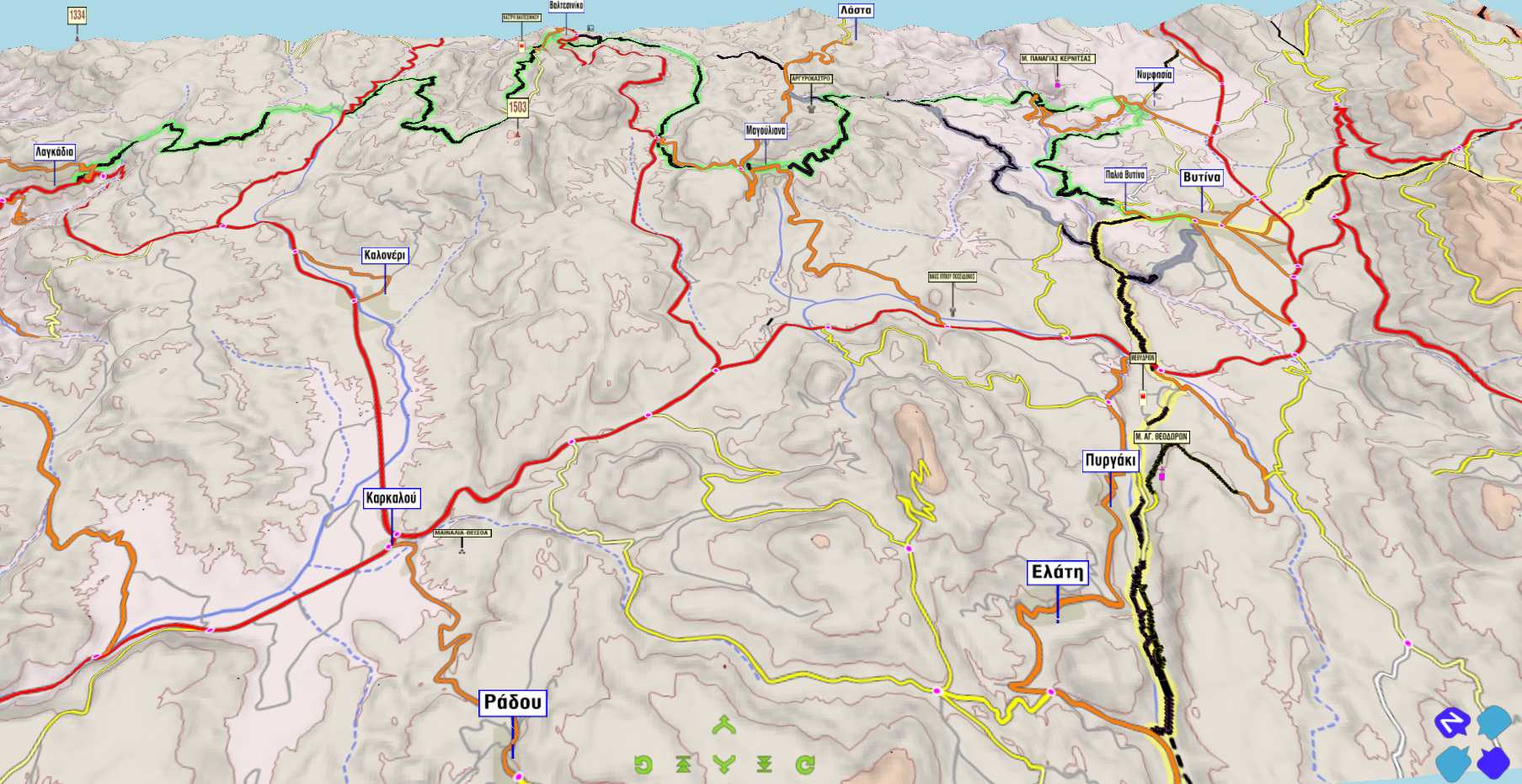
Sections 4 to 8 are crossing the puzzling terrain of eastern Gortynian mountains.