Villages
Between the villages and towns of Arcadia, Gortynia holds a special place. Stemnitsa, Dimitsana, Zygovisti, Elati, Vytina, Nymphasia, Magouliana, Valtesiniko and Lagadia are the first names that surface, after Tripoli when one digs into the history or geography of the Peloponnese. Designed to cross as many villages as possible, Menalon Trail is not only a path to discover nature, but also a path to the Arcadian history and geography. In each of the eight sections, Menalon Trail offers the traveler the opportunity to revive his interest or complete his knowledge on history and geography. Nine nodes, nine villages, nine protreptic suggestions of an alternative path to understand the untold human-scale topography.

Stemnitsa
Stemnitsa, the starting point of Menalon Trail, is the main hub for the Gortynian unity along with the region of Megalopolis.
Stemnitsa stands at an altitude of 1080 meters and since it was built amphitheatrically on the slopes of mount Klinitsa, part of the Mainalon range, the village developed into a secluded and limited space. The core of the settlement is structured around the main road running through a kind of ledge, while the inhabited perimeter spreads on rocky outcrops, on shaded sites near the stream or on the sunny slopes above the square.

Dimitsana
Dimitsana is built on a spacious shoulder, the unique passage in the upper valley of river Lousios, at an altitude of 1000m. The location is ideal and is inhabited since ancient times: in the “Platsa”, the outer part of the natural shoulder, sections of isodomic ancient wall are visible between the walls of newer houses, which belonged to the acropolis of ancient Tefthis, the town itself possibly located in the smoother slopes below Dimitsana, towards Paleochori.

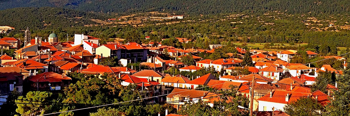
Zygovisti
A small village in the north of mount Klinitsa, between the large plateau Kampos, which constituted the main agricultural resource of the village and the fir forest of mount Menalon. The name probably comes from the place name Zygos, which was probably attributed to the area because of its vicinity to the important passage of Western Menalo (nowadays known as Bilalis). The village was colonized in the 16th century by the family of Kontogianis as they moved here from their village of Emialon in Messinia. The same family also founded in 1608 the monastery Emialon, on the crest of the ravine of Lousios, just below Zygovisti.
Elati
A small village hidden in a crease West Menalo, between the forest and the riverbeds of Mylaon. Elati has much in common with the adjacent settlements of Pyrghaki, now deserted, and the small village Methydhrio, with whom it shares a common destiny. All three ware founded in the period of the economy of survival, when villages originated and sustained spontaneously among the limited resources of the forest and meadows of the mountain.
Vytina
The modern Vytina spreads on the level plateau at the foot of mount Menalon, in an area that used to be an important agricultural resource. The settlement resulted from the fusion of previous settlements, including Old Vitina and other rural settlements. Vytina developed such a dynamic it had soon lowlands branches in Argolida, Achaia and Ilia. Because of this dynamic, but also of its position on the roads networks that developed in the first half of the 20th century, Vitina assumed the role and functions of an enlarged regional hub. The old Sanatorium and the School of Forestry were the forerunners of the mountain resort you see today.

Nymfasia (Granitsa)
A small village, built on a smooth saddle of the Mylaon valley. Nymfasia is closely connected to its regional center, Vitina, and thus offers complementary activities and facilities. The parish church of Aghia Triada in the center of the village, it is a stone-built basilica of the late 19th century with an imposing bell tower. Τhe reconstructed fountains Karidia (“walnut”, original construction of 1824) and Mousgha (1876) are both stone-built and located in the perimeter of the village on the way towards the monastery of Kernitsa.

Magouliana
For the beauty of the amphitheatrical location at the head of the valley Kamari and the security provided by the medieval fortress Argirokasto, Magouliana climbed higher than any other village in the Peloponnese, reaching 1,240 meters. The village occupies the entire basin, facing south and exposed to the sun all day long, thus softening the effects altitude might otherwise have.
Valtesiniko
Valtesiniko is built across a small and sunny basin, among important and extensive agricultural, forestry and livestock resources. The agricultural area of the village occupies two large areas, the valley of Ela and the Valtesiniotiko Plain; in the lower zones of the communal area, endless wintering terrain for livestock can be found, while a vast forest stretches to Magouliana, Kaloneri and Kryovrysi.

Lagkadia
Lagkadia is built on very steep slope of the Gortynian mountains, in an area which, despite the fact it makes the construction of buildings particularly complex, it has many qualities: it’s located on the obvious geographical connection of Gortynia towards the west (from here passed the ancient road connecting Sparti, Megalopoli, Methidrio and Theuthis to Olympia, the route used in Ancient times by all those going from eastern Peloponnese to the Olympic Games in Olympia), it has many springs and provides natural defense and safety conditions.