European Trails

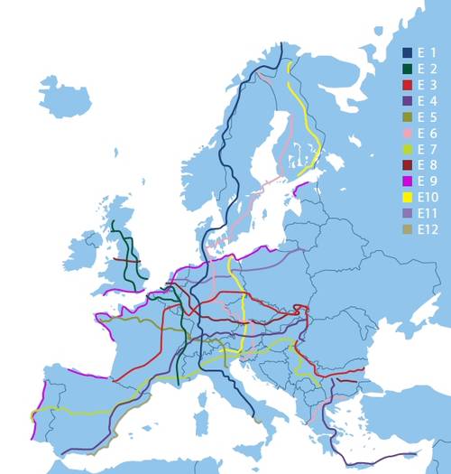
The European Long Distance Paths cross the whole of Europe, from the North Cape countries to Crete and from the Atlantic Ocean to the Carpathians and the Black Sea. Total is 12 tracks, bearing the characteristic mark and are numbered from E1 to E12. The European Paths designed, labeled and maintained by the national members of the European Federation of Hiking (ERA). The European Paths combined with existing national or regional routes and create local networks. The alignments of the European Path E1 through E12.
E1. Nordkapp (N) – Göteborg (S) – Konstanz (D) – Lugano (CH) – Genua (I) – Salerno (I). Length: 7.000 km
E2. Inverness (GB) – Hoek v Holland (NL) – Antwerpen (B) – Echternach (L) – Chamonix (F) – Nice (F). Length: 4.850 km
E3. Santiago (E) – Vézelay (F) – Echternach (L) – Fulda (D) – Zakopane (PL) – Ártánd (H) – Nesebâr (BG). Length: 6.950 km
E4. Tarifa (E) – Grenoble (F) – Budapest (H) – Beograd (SRB) – Sofia (BG) – Lanaca (CY). Length: 11.800 km
E5. Pointe du Raz (F) – Fontainebleau (F) – Kreuzlingen (CH) – Bregenz (A) – Verona (I). Length: 2.900 km
E6. Kilpisjärvi (FIN) – København (DK) – Goslar (D) – Koper (SLO) – Alexandroupolis (GR). Length: 6.300 km
E7. El Hierro (E) – Lisboa (P) – Andorra (AND) – Nice (F) – Ljubljana (SLO) – Nowi Sad (SRB). Length: 4.330 km
E8. Dublin (IRL) – Hull (GB) – Hoek v Holland (NL) – Bonn (D) – Wien (A) – Košice (SK) – Svilengrad (BG). Length: 4.390 km
E9. Lisboa (P) – Brest (F) – Hoek v Holland (NL) – Lübeck (D) – Gdansk (PL) – Tallin (EST). Length: 5.200 km
E10. Nuorgam (FIN) – Potsdam (D) – Praha (CZ) – Salzburg (A) – Bolzano (I). Length: 2.880 km
E11. Scheveningen (NL) – Osnabrück (D) – Potsdam (D) – Poznań (PL) – Ogrodniki (PL). Μήκος: 2.070 km
E12. Sceuta (E) – Barcelona (E) – Nice (F) – Genova (I) – Salerno (I). Μήκος: 1.600 km


